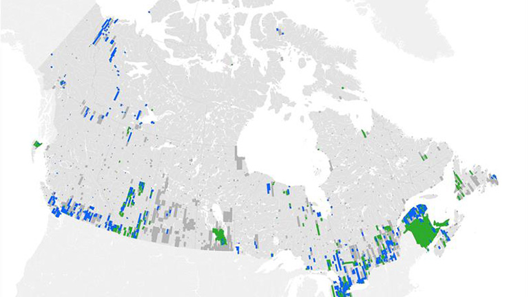
GeoAI

A time-enabled topographic feature series.

On this page

Learn about the GeoAI Series, the core geospatial data created using Artificial Intelligence (AI) developed by the Canada Center for Mapping and Earth Observation.

About GeoAI: fast, accurate and high resolution

The GeoAI Series is a collection of topographic features that are:

  • Natural or artificial, including roads, buildings, lakes, rivers, and forested areas
  • Based on high-resolution image sources
  • Time enabled
  • Automatically extracted by artificial intelligence algorithms

Why GeoAI?

GeoAI automates the data creation process, enabling Natural Resources Canada to drastically increase efficiency and boost its production rate. This allows us to quickly generate data and produce more up to date information when and where it’s needed.

Resolution

GeoAI features are generated from very high-resolution imagery (about 50 cm or better) thereby providing detailed and accurate data to users.

Figure 1: Example of high-resolution features extracted from a 2023 satellite image (MAXAR Technologies © 2025) acquired over a suburban area of Calgary, Alberta.

GeoAI accuracy

All AI models developed by NRCan are benchmarked against a comprehensive validation dataset, representative of the Canadian landmass. Only the highest performance models are retained to produce the GeoAI: GeoBase Series.

GeoAI for time-enabled analysis

The GeoAI data captures a topographic snapshot of an area at a specific moment in time. By layering multiple snapshots, users can easily view and analyze changes over time.

This example highlights an analysis of urban development for Quebec City between 2006 and 2022 created using GeoAI datasets.

Figure 2: Change detection process over Quebec city, Quebec, between 2006 and 2022.
Map of GeoAI feature coverage across Canada

GeoAI Data Index

Find areas that currently have GeoAI coverage and download the data.

Map created with GeoAI features

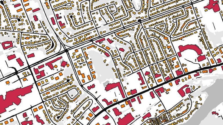
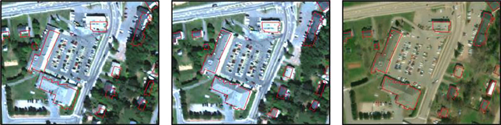
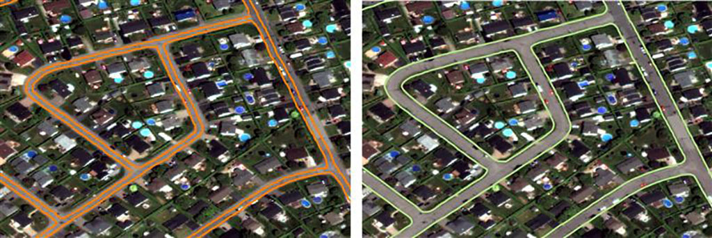
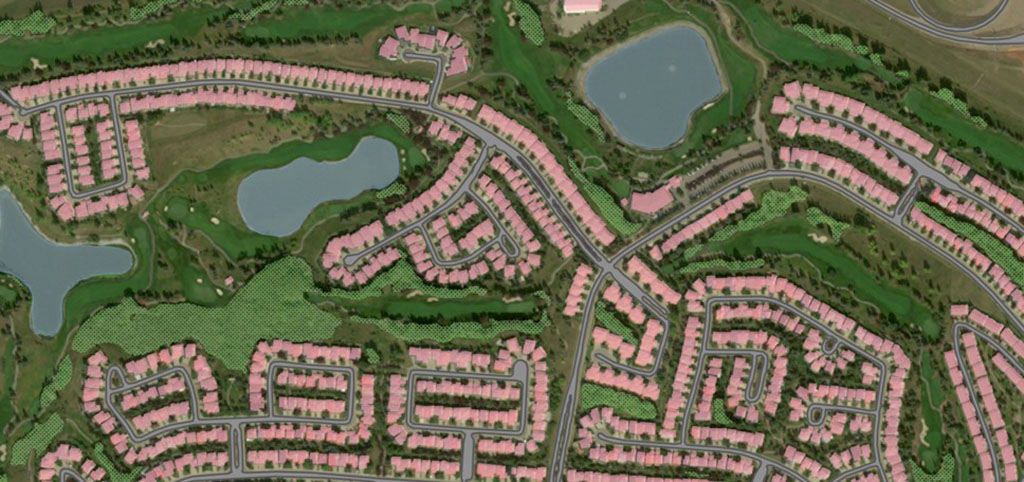
GeoAI Feature Series

Access the GeoAI metadata and download the available datasets.

Map of a change detection analysis in Québec City

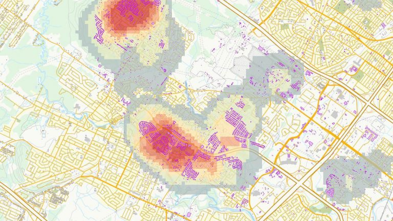
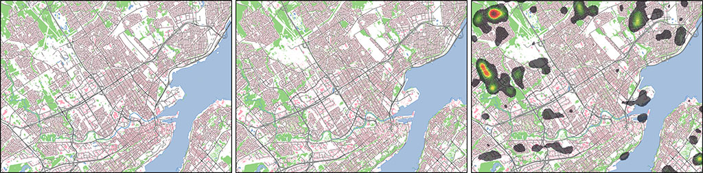
Urban Development Use Case

Explore the results of a change detection analysis in Québec City.

What's next for GeoAI

We’ve invested a lot of time and effort into building the groundwork for the GeoAI: GeoBase Series, but that’s just the first step. We still have plenty of room to grow, improve, and develop new features to transform this project into something truly cutting edge!

Things to look forward to shortly:

  • Improved classification accuracy by developing and training new models with larger and more diverse training datasets.
  • Improved horizontal accuracy, by matching the source images used to the very accurate High Resolution Digital Elevation Model (where available).
Figure 3: Comparison of current (left image) and upcoming (middle image) horizontal alignment process of satellite image from 2020 (MAXAR Technologies © 2025) with additional sources of horizontal alignment (3D building footprints extracted from LiDAR: red polygons), and from an independent source (right image: BING imagery © Microsoft).
  • Improved post-processing for cleaner and more representative features.
Figure 4: Example of improvement for the post processing with current (left image) and upcoming (right image) processes for roads extracted from a 2016 satellite image (MAXAR Technologies © 2025).

Check back regularly to keep informed on the latest updates and announcements about GeoAI.

Product background

Since 2019, the Canada Centre for Mapping and Earth Observation (CCMEO) has invested significant strategic efforts in developing cloud-based geospatial data management systems and advanced AI.

These efforts led to the launch and open distribution of the Geo-Deep-Learning project (access the geo-deep-learning github), aimed at enabling the use of Convolution Neural Networks (CNN) with georeferenced datasets.

Natural Resources Canada later implemented image pre-processing and geo-deep-learning tools in an operational pipeline which is used to automatically process very large quantities of aerial or satellite optical imagery (the use of other data sources is currently in development) to extract core geospatial features.

CCMEO is pioneering the integration of advanced foundation models specifically trained on Canadian multi-spectral multi-resolution and multi-temporal satellite and airborne imagery. By leveraging self-supervised learning techniques and vast archives of high-resolution Canadian earth observation data, these models are uniquely attuned to Canada’s diverse landscapes and environments. They can then be fine-tuned to automatically identify and analyze features of interest, enabling new levels of insight and innovation in geospatial analysis.

To test out the systems, validate the results, develop the dataset structure, and highlight use cases, various pilot projects were carried out in collaboration with the Canadian Council on Geomatics (CCOG). Following the completion of these pilot projects, the series was formally approved by the CCOG as a GeoBase Initiative data series.

Contact

Email geoinfo@nrcan-rncan.gc.ca to get in touch with our team, or contribute to the geo-deep-learning or geo-inference projects.