Canada’s National Elevation Data Strategy

The strategy provides high-resolution, accurate and up-to-date elevation data for Canada.

On this page

About the National Elevation Data Strategy

What is it?

The National Elevation Data Strategy (NEDS) provides accurate and up-to-date elevation data for Canada. The strategy is an initiative of the Canada Centre for Mapping and Earth Observation (CCMEO) at Natural Resources Canada (NRCan).

The NEDS develops authoritative geospatial data that supports key initiatives, including:

  • Flood mapping: defining flood-prone areas via the Flood Hazard Identification and Mapping Program and improving emergency preparedness
  • Forest management: supporting the Canadian Forest Service’s enhanced forest inventory initiatives and helping Parks Canada in developing detailed vegetation inventories
  • Hydrographic data: supplying essential data to the Canadian Hydrospatial Network
  • Telecommunications: enabling the optimal placement of antennas, with Innovation, Science and Economic Development Canada (ISED), to improve network coverage
  • Geohazard assessment: evaluating landslide risks through the Geological Survey of Canada
  • Energy planning: identifying optimal sites for wind and solar energy infrastructure
  • Environmental management: supporting water management and climate change monitoring
  • Land management: guiding the design of roads, bridges, and buildings
  • Research and development: providing core data for innovative research

The NEDS delivers national leadership, expertise, and scientific guidance for the acquisition and validation of airborne lidar data. Through ongoing collaboration with federal departments, provinces, territories, municipalities, and Indigenous communities, it ensures consistent access to high-quality 3D elevation data to improve decision-making across Canada. The strategy team also uses satellite technology to generate up-to-date, high-resolution data in more remote areas and north of the productive forest boundary.

What is lidar?

Lidar (Light Detection and Ranging) is a remote sensing technology that collects data by sending a pulse of light to an object or surface (e.g., ground, building, tree canopy) and measuring the time it takes to return to the sensor. The precise distance between the sensor and target is calculated for each pulse. The millions of data points collected create a lidar point cloud used to create high-resolution elevation data products. 

Who acquires lidar data in Canada?

In Canada, most lidar data acquisitions are carried out by the federal, provincial, territorial and municipal governments to support government programs and priorities. Collaboration is a key factor in the success of the National Elevation Data Strategy. The federal government works with all these partners to make existing lidar data accessible, to acquire new, up-to-date data in partnership, and to avoid duplication in acquisitions.

Find more information about lidar data acquisition partners across the country in the National Elevation Data Strategy partner list.

What is available?

Five national products are available through the NEDS.

View of the digital surface model of an area with a river, buildings and roads.

High Resolution Digital Elevation Model (HRDEM) - CanElevation Series

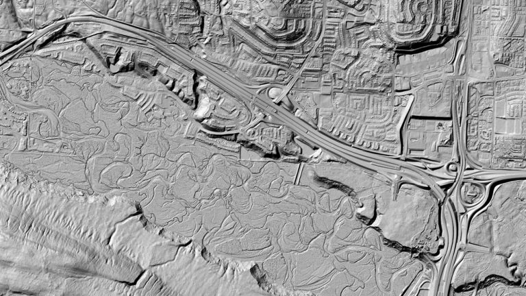
The HRDEM product is derived from airborne lidar data (mainly in the south) and satellite images in the north.

Map showing the High Resolution Digital Elevation Model extent over Atlantic Canada.

High Resolution Digital Elevation Model Mosaic (HRDEM Mosaic) - CanElevation Series

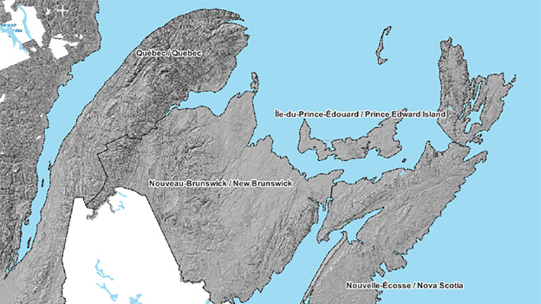
A unique and continuous representation of the high-resolution elevation data available across the country.

Map of Canada of the Medium Resolution Digital Elevation model coloured relief.

Medium Resolution Digital Elevation Model (MRDEM) - CanElevation Series

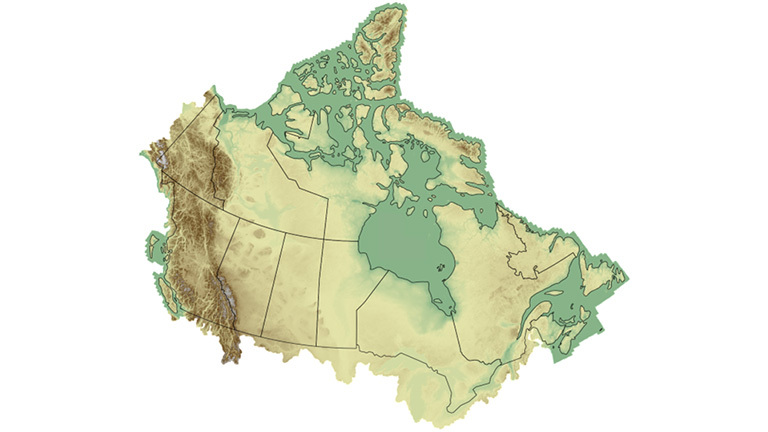
This product provides a complete, 30 metres resolution, nationwide coverage for Canada.

Mosaic of images of lidar point clouds showing features like a windmill and bridge.

LiDAR Point Clouds - CanElevation Series

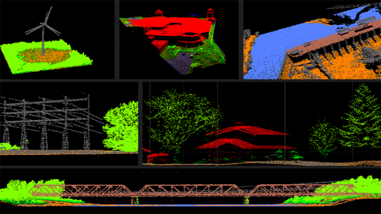
This product contains point clouds from airborne lidar acquisition projects conducted in Canada.

Colour-shaded relief map of a river valley with three dimensional footprints of buildings.

Automatically Extracted Buildings

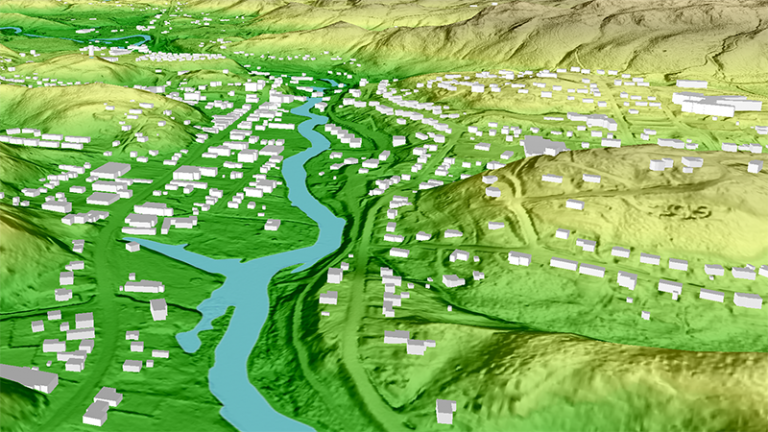
Polygonal building footprints automatically extracted from lidar data, including the minimum and maximum elevations of each building..

What’s the difference?

Product

High Resolution Digital Elevation Model 

Medium Resolution Digital Elevation Model

Model(s)

DTM and DSM

DTM and DSM

Status

Ongoing

Ongoing

Coverage

Partial

Complete

Temporal extent

2006 to present (for exact data source dates, see product specs.)

2006 to present (for exact data source dates, see product specs.)

Data source

Airborne lidar data and DEMs derived from stereo satellite imagery

HRDEM from lidar data (where existing) and Copernicus GLO-30 DEMs

Resolution

1m or 2m

30 m

Vertical accuracy (on bare-earth surface)

<50 cm when the source is lidar and <2m when the source is satellite imagery

~1.6 m when the source is HRDEM and ~2.6 m when the source is GLO-30.

Vertical datum

CGVD2013

CGVD2013

The map gallery displays a collection of interactive maps that showcases geospatial datasets, allowing users to explore and visualize Canada’s elevation data, such as high-resolution DEMs and relief maps.

High Resolution Digital Elevation Model (HRDEM) Mosaic

Check out the High Resolution Digital Elevation Model Mosaic (HRDEM Mosaic) which displays both DSM and DTM hill shaded layers.
The Atlas of Canada Relief map.

The Atlas of Canada’s Relief Map of Canada (atlas.gc.ca)

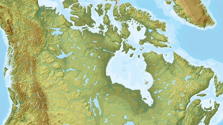
The 2024 Atlas of Canada Relief Map displaying elevation as colour-shaded relief. Available as interactive or wall map download.

More resources

The National Elevation Data Strategy

Learn more about the strategy to increase availability and coverage of high-resolution elevation data.

Elevation Data

Learn more about elevation data, why it is important and how it is being collected in Canada.

CSA W229.1:25 Airborne lidar data acquisition

Explore the Airborne lidar data acquisition Standard to plan for lidar acquisition projects.

Geospatial News

Follow announcements of new data releases.